We use your sign-up to provide content in ways you’ve consented to and to improve our understanding of you. This may include adverts from us and 3rd parties based on our understanding. You can unsubscribe at any time. More info
The entire UK is braced for ‘very severe’ weather from tonight as two monster storms smash the nation with torrential, rain, gales and wintry downpours.
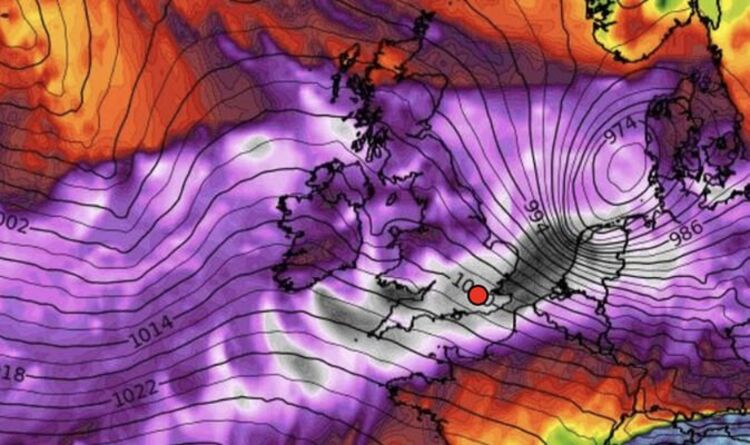
The full force of Storm Dudley will plough through Britain on Wednesday closely followed by Storm Eunice on Friday.
Both threaten gusts powerful enough to rip roofs from buildings, down power lines and knock out mobile phone coverage.
The storms will be hurled across Britain by a savage jet stream firing across the nation driven by a 200mph ‘jet streak’ core.
Government forecasters have issued a three-day slew of alerts for hurricane to storm-force winds while warning for heavy snow across swathes of Britain on Friday.
Met Office meteorologist Aidan McGivern said: “Storm Dudley will come along first and will picked up by a very powerful jet stream travelling at 200mph.

“Storm Eunice is meanwhile likely to bring some strong winds and the risk of disruptive snow across its southern flank.
“The winds really start to pick up on Wednesday evening with widespread gales which could reach 80mph or 90mph along exposed coasts and hills.
“Then on Thursday, out of nowhere, Storm Eunice forms and deepens very quickly as it approaches the UK.
“Across the north there is the risk of significant, disruptive snow and even blizzards.
Met Office meteorologist Alex Deakin echoed the caution while warning nowhere over the next three days will escape the brutal onslaught.
He said: “We are in for some very lively weather through the rest of the week, so be prepared for some very wet and some very, very windy conditions.
“Dudley will mostly affect Scotland and northern Britain while Eunice will be coming in from the south.

“Everywhere is going to be affected by these storms and both have the potential for significant disruption and damage.”
Coastal regions will be in the firing line for monster waves hurled over sea defences by raging winds, he warned.
“Big powerful waves and dangerous coastal flooding is a risk with these storms,” he added.
Britain’s chaotic weather is being stirred up by a powerful jet stream and a strong stratospheric polar vortex.
This circling channel of winds high over the North Pole has been firing at exceptionally high speeds since the start of the year.
It is showing signs of dipping into the troposphere–the layer of the atmosphere closest to ground level–through the coming days.

Netweather forecaster Nick Finnis said: “The exceptionally strong stratospheric polar vortex since the start of the year, record-breakingly strong for a few days recently, looks to finally couple fully with the troposphere.
“This means a strong polar vortex through all levels of the atmosphere is looking most likely as we see out meteorological winter.
“It is likely the UK will see a continuation of strong zonal westerlies with a conveyor of lows passing over or north of the UK bringing spells of wet and windy weather at times and generally it will be on the mild side.”
Mr Deakin added: “We have got a strong polar vortex at the moment.”
Weather models reveal the centre of Friday’s storm to plunge from 980 millibars to 940 millibars in 24 hours as it approaches the UK.
This quick deepening, or explosive cyclogenesis, also gives rise to the terms ‘weather bomb’ and ‘bomb cyclone’.
Motoring groups have warned drivers to take extra care while out and about through the coming days.
RAC Breakdown spokesperson Rod Dennis said: “The strength of the wind brought about by Storm Dudley will make driving conditions extremely difficult, so we urge people to delay their journeys until the storm passes.
“Some areas may see snow accompanying the strong winds, a particularly dangerous combination and one that has the potential to be extremely hazardous for drivers.”
The Met Office has an amber warning for wind across northern Britain from Wednesday with another wider-reaching yellow warning to remain in force until Thursday.
Another yellow alert covers England on Friday when Eunice unleashes gusts strong enough to damage buildings and cause major power outages.
A Met Office spokesman said: “In addition to the wind, there is the potential for a period of snow and perhaps blizzard conditions, most likely over northern England, parts of Scotland, Northern Ireland and north Wales.”
Weather charts show winds reaching 70mph on Wednesday and upwards of 93mph on Friday.
Source: Read Full Article
