BBC Weather: Temperatures to rise as sunny spells hit parts of UK
We use your sign-up to provide content in ways you’ve consented to and to improve our understanding of you. This may include adverts from us and 3rd parties based on our understanding. You can unsubscribe at any time. More info
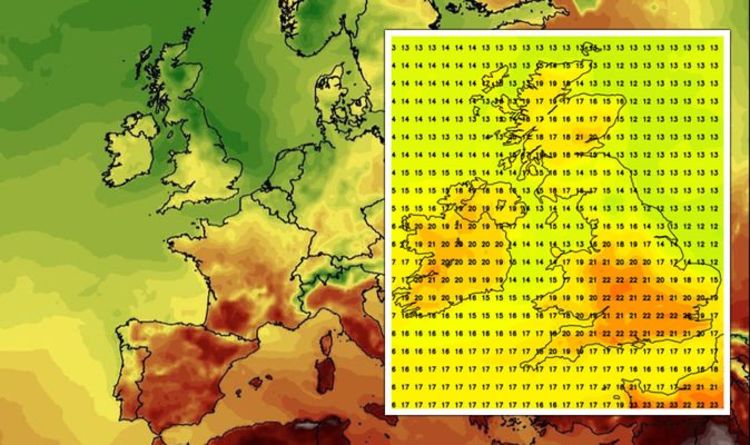
Following a blast of hot weather this weekend, forecasters are predicting high temperatures running into the middle of next week. Due to a blast of hot air travelling up from Southern Europe, passing through France, temperatures will remain in the low 20s for many in the country on August 31. According to graphs from forecaster, Netweather, for large parts of England, temperatures will reach 22C (71.6F).
For London, the south coast and parts of the Midlands, temperatures will range between 21-22C next Tuesday.
These temperatures will remain on September 1, with the south coast recording highs of 21C.
Liverpool and certain parts of the North-West of England will also see the mercury rise to 20C (68F).
The late-summer blaze will continue on September 2, with the south, north-east and east coasts seeing levels of 21C.


These high temperatures for the time of year have been caused by a Mediterranean plume which has caused the mercury in Spain, Portugal, Italy and Greece to rise to 35C (95F), according to graphs from WXCharts.
Speaking to Express.co.uk, Alyssa Smithmyer from AccuWeather said multiple areas will the mercury remain above normal levels heading into September.
She said: “A current look at how temperatures are faring with respect to what is average for this time of year is that most places across the United Kingdom is a few degrees above normal.
“There is currently an area of high pressure lingering over the United Kingdom, which is allowing for largely fine and settled weather.
JUST IN: Brexit LIVE: EU issued legal warning over bid to block UK

“This feature can also contribute to warmer air across the region since this warm air mass travelled northward from the west coast of Portugal and originated from much warmer regions.
“This area of high pressure will linger throughout this week but will eventually adapt to the relatively cooler northern air and lose its warm influence.
“As we look at the next few weeks, however, the general pattern as we shift through this last week of August and into the month of September is that much of southern England will see temperatures close to what is average for this time of year, perhaps a few select days hovering a few degrees slightly above the average daily temperature.
“But the pattern for areas, including London, look to remain close to normal.
DON’T MISS
BBC Weather: Scorching 26C temperatures to blast UK beating average [Report]
UK weather: Britain braced for torrential rain and howling winds [Latest]
UK long-term forecast: Heatwave predicted to hit bringing 25C highs [Insight]


“In reference to that, ‘normal’ temperatures across London for the last week of August hover around 68-69 degrees F (20-20.6C) typically.
“Normal temperatures by the last week in September are expected to slowly lower to be around 62-64 degrees F (16.7-17.8C).
“As we look at the pattern set up for central England and northern regions of the United Kingdom, however, it points to slightly warmer than normal temperatures being recorded for the next few weeks.”
Such is the blast of sunshine that WXCharts is reporting temperatures rising to 4C above what is normally expected for the time of year.

These abnormal temperatures are expected across the entirety of the UK.
The last of the late-summer blast is expected to end on September 3, with the mercury remaining at 22C (72F) in the South-East of England.

On September 4, however, temperatures are expected to plummet as the UK heads into autumn.
Source: Read Full Article
