UK Weather: Met Office forecast spells of rain
We use your sign-up to provide content in ways you’ve consented to and to improve our understanding of you. This may include adverts from us and 3rd parties based on our understanding. You can unsubscribe at any time. More info
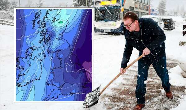
An Arctic blast will soon leave the UK in a week-long -5C freeze, weather maps have predicted. A series of maps released by WXCharts show that the last month of winter could prove tricky for millions of Britons, with the mercury tipped to plummet across England, Scotland, Wales and Northern Ireland. The frigid temperatures will bring another round of deep snow, especially in northern areas of the UK’s home nations.
WXCharts maps show that, despite this week’s comparatively warm weather, the country will grow much colder starting this weekend.
Temperatures will decrease by more than 15C in some places as they plummet from today’s (February 1) highs of 5C to 10C down to the minus range on February 4.
Scotland, Northern Ireland, and northern regions of England and Wales will see the lowest temperatures settle at -10C.
Britons living in the southeast, including London, will endure lows between -1C to -5C.

Maps show that, after a brief respite on February 5, the deep freeze will stay for the foreseeable future.
Temperature forecasts from WXCharts covering February 7 to 17 show the mercury will remain below -5C.
A wave of cold drifting from the east will keep the UK frozen in consistent lows of -15C, WXCharts data shows.
The maps show the probability of falling snow will shoot up across the country around the same time.


As the chilly trend starts on February 7, snowfall will spread across the country.
Maps show that snow showers in Scotland and parts of the Midlands will eventually consume almost all of England and Wales by February 12.
Settled snow will reach between one and two inches widely, with patches of four, six and up to nine inches in isolated areas.
Snowfall trends alongside the plummeting temperatures until February 17, when some areas will see totals reach 13 inches.


Speaking to Express.co.uk, Jim Dale, the founder and the Senior Meteorological Consultant at British Weather Services, said the upcoming cold spell “could be described as a Beast from the East”.
But he said the “jury’s out” as to how significant the coming weather systems could become.
He said: “Right now we’re looking at two models.
“One model is pulling in easterly [weather] in around eight, nine, 10 days’ time – the other isn’t. At the moment, the jury’s out.”
Ultimately, Mr Dale said it would “be a few days” before forecasters can provide a conclusive picture of the weather.
He added: “I fancy we will see some cold eventually – it’s just how deep it goes.
“There’s plenty of time yet, even in the second half of February, for things to turn around. Even March can deliver debilitating snow at times.”
But he said he was certain that warmer, high-pressure weather would come in on Saturday.
Source: Read Full Article