FLOODING is expected to hit Britain in the coming days as an Arctic blast edges closer – bringing with it heavy rain, gale force winds and freezing overnight temperatures.
Yesterday saw torrential rain sweeping across the country, with more wet weather set for this evening as a dreary January well and truly sets in.
A patchwork of drizzle, dry spells and even some sun has been seen today – with extreme weather in some parts.
For tomorrow, a Met Office forecast says: "Mostly cloudy, cloud thick enough for some rain or drizzle at times, mainly in the north and west. Mostly dry in the southeast where some brighter spells. Milder than Sunday."
Meanwhile temperatures will plunge, with the mercury dipping below zero overnight in Northern Scotland and hitting just one degree in Dumfries from 9pm tonight – while Aberdeen will be shivering in temps of -3C.
.Read our weather live blog for the latest news and forecasts
- Louis Allwood
Cardiff evening and night forecast
One or two showers across Wales at first this evening, but some clear periods for many.
Through the night it will turn cloudier, with rain and drizzle arriving from the west, this turning locally persistent by dawn.
Becoming milder later. Minimum temperature 3 °C.
- Louis Allwood
London evening and night forecast
Dry overnight with any showers clearing and winds easing. Some clear spells allowing temperatures to fall close to freezing.
Perhaps the odd mist or fog patch developing in prone spots. Cloud thickening by dawn to give an overcast start.
Minimum temperature 1 °C.
- Louis Allwood
Tuesday to Thursday outlook for UK
Cloud and rain for England and Wales Tuesday, clearing southeast; sunny spells elsewhere with a few showers far northwest.
Settled and mostly dry Wednesday onwards, with overnight frost and fog.
- Joseph Gamp
Long range forecast from January 22 to February 5
Conditions expected to remain broadly unsettled and changeable through this period with occasional spells of cold, wet and windy weather moving across from the Atlantic.
Western and northwestern parts likely to see the wettest and windiest conditions overall whilst eastern and southeastern parts probably seeing the most of any drier spells.
Temperatures likely to be slightly above average overall throughout, but there remains a possibility of short-lived colder spells.
Colder spells likely to bring a risk of snow at times, though mostly over high ground in the north.
Possibility that stronger systems will bring gales to western and northwestern areas throughout this period.
- Joseph Gamp
Weather outlook for Tuesday to Thursday
The Met Office has offered a short summary into the weather for next week.
It predicts how there will be "cloud and rain for England and Wales Tuesday, clearing southeast; sunny spells elsewhere with a few showers far northwest".
The agency added it will be "settled and mostly dry Wednesday onwards, with overnight frost and fog".
- Joseph Gamp
When is it too cold to go to work?
Snow and ice have reappeared across Britain after a record mild spell to start the new year.
And though everyone loves a snow day, there’s unfortunately no guarantee of a day off school or work just because it’s snowing.
There is also no specific law around minimum or maximum working temperatures, although there are guidelines.
If it is safe and reasonable to travel to work, then you should do so.
But if it isn’t safe, contact your employer and check the company handbook.
Keep in mind that government guidance in all four UK nations currently advises you should work from home if it’s practical, too.
- Joseph Gamp
Make your car visible in poor winter weather
You can be fined up to £1,000 for failing to switch your car lights on when you’re driving.
Make sure they’re all working before you set out on your journey, and turn them on if you have to get out to clear snow.
If you use fog lights, remember to switch them off when visibility improves so they don’t dazzle other drivers or obscure your brake lights.
- Joseph Gamp
This month will see drop in temperatures, says Met Office expert
Met Office forecaster Craig Snell said the average temperature in December and the beginning of January is usually around 7C or 8C, with the warmer weather due to a south-westerly wind making its way across the country.
The higher temperatures are usually localised, but “plenty of places” have seen highs of 15C over December.
However, he added that January could see a drop in temperatures because of an Arctic chill sweeping through from next week.
- Joseph Gamp
Met Office says 'sunny spells for many' this afternoon
The Met Office this lunchtime tweeted: "Here's the latest update for this afternoon.
"Sunny spells for many. Showers along western coasts.
"Cloudier and drizzly in the southwest later."
- Joseph Gamp
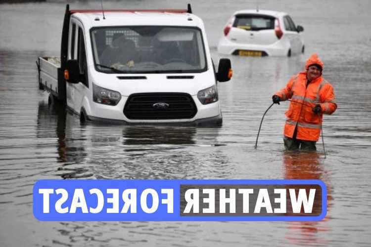
Pictured: Cars drive through floodwater in Godalming, Surrey
Heavy rainfall has today led to surface flooding across the Home Counties.
The image below shows vehicles driving through floodwater in Godalming in Surrey.
It comes as wet & windy weather sweeps across Britain today.

NINTCHDBPICT000703992636Credit: Alamy - Joseph Gamp
How is tonight's weather shaping up?
Early evening showers over northern England and East Anglia fading.
Most areas turning cloudier overnight with rain at times in the west.
Risk of fog patches away from the west.
- Joseph Gamp
Met Office weather summary for today
The Met Office says Sunday will see "early showers in the north and west, heavy at times, will become mostly confined to parts of northern England by mid to late afternoon.
"Cloud and rain then developing in the southwest this afternoon and otherwise mostly fine and dry," it added.
- Joseph Gamp
Weather is 'starting to improve' today
The weather is starting to improve on Sunday in the south and east with the showers remaining in the north until late afternoon
Maximum temperatures in the South of the UK are forecast to reach around 10C or 11C. In the North of England around about 7C or 8C.
Forecasters have said parts of the UK can be hit by "icy stretches" and snow with temperatures set to plummet as low as minus 4C in higher areas of Scotland and averages of 2C for most of the rest of the UK.
Western Scotland, Northern Ireland, north-west England and North Wales could face frosty conditions, caused by showers expected to last until Sunday morning, according to the Met Office.
- Joseph Gamp
Met Office: Rain to clear in the east today
According to the Met Office, today will be rainy "clearing eastwards, finally clearing East Anglia and southeast England late afternoon."
The blustery showers are set to continue at night particularly in the north and the west with hail expected to fall in parts of the country.
The forecast states: "Some early hill snow in the North. Brighter, colder weather with heavy, blustery showers, wintry over hills, follows from the West. Windy and blustery."
- Joseph Gamp
Heavy showers expected at the beginning of next week
Jason Nicholls, forecaster at AccuWeather, told the Express: “A front will bring some rain to the UK Saturday with snow in the Scottish Highlands.
“Another front will spread showers southward across the UK Monday night and Tuesday.
“There can be some snow in the Scottish Highlands again Monday night. The remainder of next week looks dry with high pressure in control.”

- Joseph Gamp
Met Office: Cold and frosty start this morning
The Met Office tweeted: "Planning a #Sunday morning walk or just looking forward to a lie in?
"It will be a #cold and #frosty start to the day, but many of us will see some sunshine.
"Scattered heavy showers will affect some northern and western areas and these will drift east through the morning."
- Joseph Gamp
Warnings over widespread ice
BBC forecaster Christopher Blanchett said: “Through the course of this evening and overnight, our concern is with ice and there is a Met Office yellow warning in force through west-central Scotland and the south.
“There is a chance of icy patches almost anywhere and under clear skies, temperatures are readily falling away to sub-zero and in rural parts of the northeast perhaps -6C.”
- Joseph Gamp
How to stay warm when outside
With the weather getting chillier and frostier, you’ll want to wrap up warm.
Here are some good tips for staying all snugly and cosy when outdoors:
- Prewarm your clothes.
- Invest in some quality thermals.
- Fleece leggings.
- Hand warmers.
- Cover every inch of skin.
- Eat fatty foods.
- Thermal flask.
- Keep moving.
- Keep hydrated.
- Keep your head covered.
- Tactical scarf-wearing – including keeping your nose and mouth covered
- Louis Allwood
Snow to hit Britain this weekend
Brits are set to freeze this weekend with the mercury expected to drop at nighttime and snow falling in the north.
It comes after drivers were urged to stay alert on the roads on Friday with ice warnings covering half the country.
And the threat continues, particularly in Scotland, where there remains a high chance of ice patches throughout the country.
BBC forecaster Christopher Blanchett said: “Through the course of this evening and overnight, our concern is with ice and there is a Met Office yellow warning in force through west-central Scotland and the south.
“There is a chance of icy patches almost anywhere and under clear skies, temperatures are readily falling away to sub-zero and in rural parts of the northeast perhaps minus 6C.”
- Joseph Gamp
Outlook for January 12-21
High pressure is expected across southern and central parts of the UK at the start of this period, bringing settled conditions and light winds, though it’s likely to be rather cloudy in some areas.
Temperatures will be generally around average, but there is a risk of some colder nights with local frost and fog.
Spells of rain, drizzle and stronger winds are likely further north, with temperatures near to or slightly above average here.
Confidence decreases through the period, but a return to generally more unsettled conditions across the UK is likely later on, with western and northwestern parts expected to continue to see the wettest and windiest weather.
Temperatures likely to remain around average.
- Louis Allwood
Weather forecast for the new week
Outbreaks of rain spreading east Monday, southeast staying dry.
Brightening from the northwest Tuesday and Wednesday, but overnight fog patches.
Cloud and blustery showers in the north.
- Louis Allwood
This month will see drop in temperatures, says Met Office expert
Met Office forecaster Craig Snell said the average temperature in December and the beginning of January is usually around 7C or 8C, with the warmer weather due to a south-westerly wind making its way across the country.
The higher temperatures are usually localised, but “plenty of places” have seen highs of 15C over December.
However, he added that January could see a drop in temperatures because of an Arctic chill sweeping through from next week.
- Louis Allwood
This week will be feeling colder for all
Met Office forecasters warned: “Cold northerly air dives south across the whole of the UK with brisk winds.
“It’s feeling colder for all, especially in the wind.”
In the capital, temperatures will plummet by 10C, from 16C at the weekend to just 6C today.
Meteorologist Simon Partridge said we’re facing a “shock to the system” as the chilly winds make it feel as cold as -2C.
“It will definitely be colder, so if you’re going out, think about an extra layer,” he said.
“You might need anything to keep the wind out because it’s not going to be pretty.”
- Louis Allwood
How cold does it have to get in order to be sent home?
There isn't a set temperature where employers have to send their employees home because it's too cold.
And since October 2012, there's no minimum temperatures in English schools, either.
The School Premises (England) Regulations 2012 don't specify a safe classroom temperature, although the National Education Union advises a minimum of 18C.
In the workplace, it's the employer's responsibility to ensure that the workplace has additional heating if the temperatures do get too cold.
Employers are recommended to include flexible working hours or rotas to help reduce the effects of a cold snap – but they don't have to.
Kate Palmer, head of advisory at employment law consultancy Peninsula, told The Sun an employer has no obligation to pay an employee if they fail to turn up for work because:
- The weather is bad
- Public transport is not running
- They miss hours because they turned up late
Plus, employees do not have a legal right to be paid in the event they take an emergency day off with their children.
- Louis Allwood
When is it too cold to go to work? (Continued…)
Employers are not required to pay employees if they cannot get to work in bad weather, according to government rights.
You could be asked to work from home, but if this isn't possible you may be asked to take unpaid or annual leave.
In the workplace, the mercury shouldn't dip below 16C and employers should try to increase temperature in the office or workplace.
The Health and Safety Executive (HSE) states that a workplace should provide "reasonable comfort".
Its Workplace Regulations 1999 state employers should "assess risks to health and safety and act where necessary (i.e. if the workplace temperature drops below the minimum guideline or if it is felt the temperature is too high)".
Source: Read Full Article