BBC Weather: UK set for cold and wintry showers
We use your sign-up to provide content in ways you’ve consented to and to improve our understanding of you. This may include adverts from us and 3rd parties based on our understanding. You can unsubscribe at any time. More info
Britain is set to be hit by a spell of wintry weather and winds of up to 80mph. The Met Office has said “cold Arctic air” is set to arrive, with a “bitter wind chill” on Friday and Saturday.
The Met Office has already issued two yellow wind warnings for large areas of the country over the weekend.
Snow showers are expected across Scotland, northern England and Wales from Friday.
Grahame Madge from the Met Office said: “We’ve got an unsettled period of weather over the next few days, with wind warnings out for Scotland and Northern Ireland to begin with on Friday.
“This will extend to the whole of the UK apart from London and the South East on Saturday, with strong winds expected.


“There is an increasing signal of snow at higher elevations, indications suggest that areas above 200m in Scotland have the highest chance from Friday.
“There may well be temporary spells in other areas across northern England and Wales, in areas like the Pennines and Snowdonia, though this unlikely to be heavy enough to settle.”
The latest Met Office weather graphics show a band of cold-air engulfing the UK during the early hours of Thursday morning.
The maps show the whole of the country turning a shade of icy-blue as temperatures plummet towards freezing.

Into Friday, the charts show patches of white across northern parts of the UK, with wintry flurries forecast in Scotland and the North East.
BBC forecaster Ben Rich said “cold” and “turbulent” weather is on the way, including “quite significant snow to areas of north Scotland”
On Friday, he added there is a chance of “wintry showers across high ground in the west” and a “curl of a weather front bringing some quite significant snow to parts of northern Scotland through the day”.
Heading into the weekend, the wet, windy and wintry weather is expected to push further south.
DON’T MISS
France in astonishing Brexit threat to UK [INSIGHT]
Royal Family LIVE: US will ‘not accept HRH President Meghan!’ [LIVE]
UK snow forecast: -12C ‘nasty’ Arctic freeze strikes Britain [FORECAST]


Mr Rich added: “Perhaps for Wales, south west England, parts of north east England, gales are likely, severe gales in places with some areas of rain, sleet and snow, drifting southwards.
“Wintry weather only pushing eastwards on Saturday.”
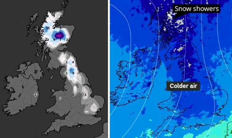
Scotland could see up to four inches (10cm) of snow by midnight on Saturday, according to the latest snow depth maps produced my WXCharts.
Parts of the North East is forecast to accumulate up to three inches (8cm) during the same period.
The maps suggest light snow showers could be fall in the Midlands and even in the South East.

The Met Office has a yellow wind warning in place across Scotland from 12pm on Friday.
A second warning covering the whole of the UK, barring the South East, is in force from midnight on Friday to 6pm on Saturday.
It says: “The strongest winds will arrive across northern Scotland during Friday afternoon, before becoming more widespread overnight and into Saturday morning.
“Winds will tend to slowly ease from the north during the afternoon. The location and strength of the very strongest winds remains uncertain.
“However, gusts seem likely to reach 50 to 60 mph widely, with 70 to 80 mph possible in coastal locations, particularly in parts of Scotland and north-east England.”
Source: Read Full Article